Whan that Aprill with its cold snap sorta

The colde of Marche hath perced to the rote,
And bathed Arctic veynes is swich new ice,
Of which denial engendred is the flour;
Comes monthe May with its swete breeth
Inspired hath in every holt and heeth
The tendre currents, and the yonge sonne
Melts the ice and floats the boatas
Its Arctic Ice Blogging time folks, with a vengence. There is a rapid breakup, the somewhat misleading ice buildup in the sub-Arctic Sea of Okhotsk and the Baltic is going, Hudson's bay is clearing and it looks like another banner year for shipping in the Northern Passage. The Chinese fleets are setting sail as we wait. (The IUP site goes to sleep at night be back tomorrow)
UPDATE: The images now are for 6/10/2010
Eli is trying to figure out what all the little flecks in the map are when you blow it up, but still the ice is thinning rapidly, and if we go to the tape. . .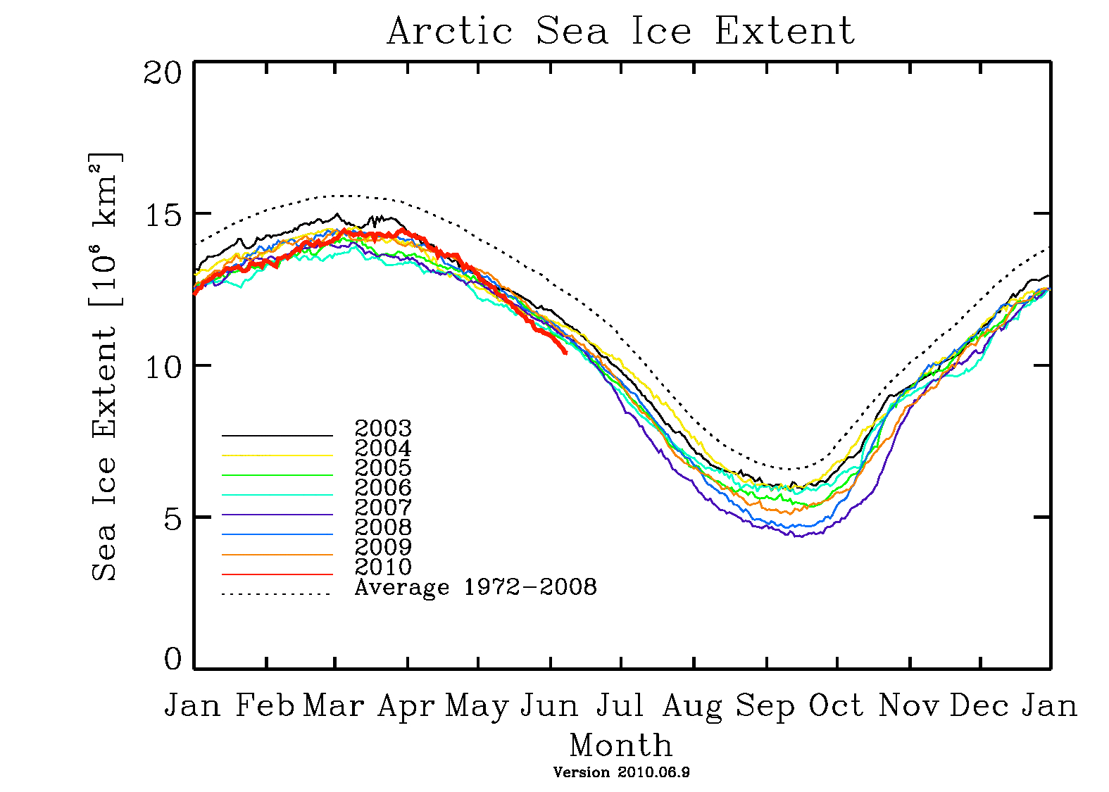
the ice extent is now under 2007 and approaching the all time low for May.
Oh yeah, as Stoat points out there is
a) either something rotten in Alabama or
b) the upper atmospheric hotspot is taking a bow
and it is the hottest April ever, or at least since we got thermometers.


20 comments:
Thank you for throwing a bone to the English majors.
jg
Compare your pic to IJIS:
http://www.ijis.iarc.uaf.edu/en/home/seaice_extent.htm
But it is interesting.
Eli thinks that IJIS may be counting more ice in the region near Japan (sea of okhosk) which really got frozen up this year like crazy, but the breaks and the trends are the same, and right now the only real diff btw IJIS and the guys from Bremen is 2005.
Tora Tora Tora
As I said at the Stoat's nest, it'ss interesting to compare the CT and Bremen maps with what the eyes in the sky are telling us, over at the MODIS Rapid Response Team's daily Arctic Mosaic. Click on the 1km/pixel view, and then compare and contrast...
Chinese Fleets?
... it looks like another banner year for shipping in the Northern Passage. The Chinese fleets are setting sail as we wait.
Is it I, God, or who, that lifts this arm? But if the great sun move not of himself; but is as an errand-boy in heaven; nor one single star can revolve, but by some invisible power; how then can this one small heart beat; this one small brain think thoughts; unless God does that beating, does that thinking, does that living, and not I. By heaven, man, we are turned round and round in this world, like yonder windlass, and Fate is the handspike. And all the time, lo! that smiling sky, and this unsounded sea!
I recommend looking at the MODIS pics. Not because they provide any really useful information, but just because they are so cool to look at. Check 'em out. The polyanas are impressive.
As someone new to the MODIS pics, I have to ask - is ice north of Svalbard supposed to be that broken up at this time of year? It looks like rubble (really big rubble, but still).
I swear, Henry Larsen could probably take the St. Roch through the NW passage in a couple of weeks. (Yes, Larsen is dead and the St. Roch is in a museum, but you understand what I mean. People who claim the current ice extent is natural because intrepid men in a reinforced schooner made the trip in the 1940s are idiots.)
Modis tip - if you look at the URL at the top you can change the year from 2010 to 2009 to see what it looked like a year ago (but no further back).
Modis tip: is very cool, thanks. There are obvious differences, but the extent of open leads in the Arctic basin in 2009 looks very similar to this year. Begs the obvious question... what would it have looked like 10 years ago?
Greg,
I am curious. Why does the fact that someone made the trip through the NW passage in the '40s--when we hear all the time that the arctic will soon be ice free for the first time ever--make someone an idiot? Whether or not it makes current levels "natural" or not, it does in fact fly in the face of all who say we are on the cusp of something never seen before. "Reinforced schooner" or not, they did it, did they not? Which is to say the arctic was not a solid mass year-around 70 years ago. Or are you saying they had to force their way through so the water was not "ice free" like it is predicted to be soon?
And what of Amundsen some 40 years earlier? Was his boat "reinforced" as well?
As for the pics, they are cool and will be interesting to watch as the summer approaches. Rattus, I am puzzled as I cannot locate the "polyanas" as you call them. A little help?
Hector
Both the Fram (Amundsen's vessel) and the St. Roch were "reinforced" to a very high degree--they were special-purpose vessels for use in the high Arctic and made to survive being locked in the ice pack.
The correct spelling for those openings in the pack ice is "polynyas". That is different than "pollyannas", who are a class of amiable denialists; they are related "alfredenewmans" of the "What, me worry?" school of climate pseudo-science.
And more than a bone was thrown to the English majors...
Anonymous Five
Hector, you might want to look at the Northwest Passage route that Amundsen took in 1903-06:
http://www.ub.uit.no/northernlights/images/northwest07c.jpg
and that Larson took with the St. Roch in 1940-42 (dark blue):
http://www.ucalgary.ca/arcticexpedition/larsenexpeditions
Note how the traditional Northwest Passage route turns south from Lancaster Sound at first opportunity to reach and hug the mainland north shore for most of the distance. Amundsen had to feel his way blind through these uncharted waters, and went aground several times. Larson had the benefit of maps and aerial surveys, but it still took him two seasons. Summer transit through this route is not at all uncommon today.
In 1944 (red) Larson was able to continue further west before being forced to turn south down the Prince of Wales Strait and make the passage in a single season.
However, the much more direct route west through the McClure Strait north of Banks Island was actually open briefly in 2007. Conditions in 2007 were nothing at all like those of 1903-06, 1940-42 or 1944.
Jim and one of the anonymice have mostly covered what I meant by "idiots". I have seen it claimed that the NWP must have been as open in 1944 as it was in 2007 or 2008. In 1944, Larsen and crew eased their way through narrow leads in ice that from a satellite perspective would appear nearly solid - i.e. much what most of it looks like right now, May 21st 2010. In 2008 you could have driven a superfreighter through there in open blue water.
In reply to a different anonymouse, "Chinese fleets" is a reference to this hilarious episode in speculative history
http://scienceblogs.com/deltoid/2006/11/chinese_navy_disproves_global.php
Fair enough. I too have seen it stated that the NWP was "open" in the 40's. And I agree it isn't apples to apples.
Thanks for the clarification on polynyas.
Hector
I've read some interesting pieces by a certain Patrick Lockerby, who predicts this year's melt will set a new minimum extent record, with a lot of background info and (great) pictures that led him to his conclusions:
.
Arctic Ice May 2010 (May 6th 2010)
.
and
.
Arctic Ice May 2010 Update (May 20th 2010)
.
He wrote two series on the Arctic sea ice, which are quite an interesting and thorough introduction:
.
Arctic Ice 2010 and Arctic Tipping Points
.
Just thought I'd share.
"Chinese fleets..."? I seem to recall an instruction from highest political levels to the Chinese business complex, urging them to pay attention to new opportunities opening in maritime transportation up noth ...
Take two aspirin, one cold shower and see you in the morning.
Eli, I figured out the white flecks. Take a closer look at the legend on the large version of the map. White is more dense than light purple and medium purple, but less dense than the burgundy-grape that represents solid ice.
Thanks Greg, my problem was that the flecks only started showing up in this year's pictures. I wondered if there was a change in the processing software
Post a Comment